


It seemed odd when container vessels mysteriously started keeping clear of Peter Webb’s yacht, but the AIS-related answer only appeared in harbour.
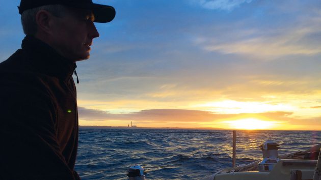
The North Sea at night: I love it. It can turn wild, like any mountain or desert, but that’s not all the time. When it’s calm, fishing lights appear, dodge about, and disappear.
Wind farm constructions march through the waves, towering above small boats, flashing red and white in the moonlight. The black waves and unseen sand banks demand respect, as does the shipping. Collision avoidance work is easier these days.

Calypso, a Contessa 32, was briefly mistaken for the naval survey vessel, HMS Enterprise. Photo: Peter Webb
One navigation aid, the Automatic Identification System (AIS), transmits small packets of (live) navigational and (pre-programmed) vessel information alongside regular VHF radio audio broadcasts, and receives similar information from others in return.
Overlay this on a chart plotter and you have a map of the surrounding traffic, or at least, of those ships with AIS functioning correctly and switched on.
North sea crossing
On a recent night crossing I found the AIS had the unexpected benefit of clearing the shipping out of the way. How did that happen? You may well ask.
Last year, I set out to cross the North Sea with my 16-year-old son. It was a late-season outing from Harwich to Ostend. And it seemed like a fine idea for a long weekend in the October half term.
We loaded food and fuel in Shotley marina. And as the light started to fade at 1700, I did reflect that the nights are much longer on the winter-side of the equinox. Not to worry.
Night had fallen by the time we reached the Landguard Cardinal. So, with waypoints for Medusa and Gunfleet set, then Trinity and Sunk West, and with the helpful glow of our trusty cockpit compass, we made our way out across King’s Channel and the traffic around the Sunk Lightship.
The Galloper turbines were flashing in lines of red in the distance, and we crossed the shallower ground of North Falls. It was a clear night and Fred kept watch for several hours while I slept. I wanted to be fresh for our next challenge, familiar to many readers, which was the main north-south shipping lanes.
Because, as any sailor who has done it will confirm, dodging ships in a busy TSS (traffic separation scheme) lane in a 10m yacht can feel very like the video game Crossy Road in which a chicken has to cross a multilane motorway. Except there is more steel and power involved, and ‘game over’ equals, at best, a long, cold swim.

Peter learned to sail on the rivers of East Anglia and the North Sea and as a student took a 17ft open boat around Spitsbergen in the Arctic. Since starting a family, camping adventures using a Canadian canoe and cruising in the Contessa 32 Calypso have taken precedence. Photo: Peter Webb
As we approached the first lane, with traffic from north to south, one freighter on our side of the lane, quite close, seemed to choose a course that took her away from us. That was interesting. But she was only a small one.
My attention was on a line of three container ships in line astern not many miles distant. According to AIS these were big; 300 to 400m in length, and going fast, at 14-18 knots.
That’s a lot of steel moving through the water in the darkness, covering a mile and a half in just five minutes; changing from a pinprick of light on the horizon to a towering, thumping great container ship in less than the time it takes to make a quick cup of tea.
But I’d done this before, and the container ships can be relied upon to hold their line. To go back to the Crossy Road analogy, I was the chicken, and it was my job to aim for the predictable gaps.
Article continues below…

Handheld VHF radio: Six of the best
Handheld VHF radios comes in all levels of specifications and a few now offer DSC and GPS features including the…

Everything you need to know about your VHF antenna
When Guglielmo Marconi began sending radio messages between coastal radio stations and ships at sea in 1897, there were plenty…
Mysterious moves
I had them all on the AIS read out, and I was wondering whether to simply stop and wait for the three of them to pass, when an odd thing happened.
The first of the three ships seemed to adjust its course away from me. So, no need to slow down for that one.
A short interval later, the second did the same thing and adjusted course. How odd. Container ships don’t do that. Then, more curious still, the third altered course to come behind my stern. Really? Was I seeing all this correctly? I wondered at the time.

Night was falling as Calypso and her father-and-son crew were clearing the coast off Harwich. Photo: Peter Webb
But my attention soon turned to the north-bound lane on the far side of the traffic separation zone. And my night watch continued.
In the event, crossing the northbound lane was easy, because those ships that were there seemed to have had chosen lines that took them clear. Well,
it was surprisingly easy, but that does happen sometimes. When I could see the way through, Fred came on watch.
Later and shortly before the late pre-dawn, the four strong flashes of the West Hinder Light beckoned and before long we ran due east to the outermost end of the buoyed channel into Ostend.
Tower blocks loomed on both sides of the leading lights and the harbour walls materialised between the two greys of sea and sky. I stepped up onto the foredeck and raised the Belgian courtesy flag, unaware of the camera trained on us. And we made the transition from the rocky open sea to calm water in the harbour basin.
The pontoons of the Royal North Sea Yacht Club had just closed for the season. It was late October, after all. So, we tied up on a waiting pontoon for the lock gates to the Mercator basin. Fred and I packed away the sailing gear and hung wet kit out to dry.
We made some coffee and watched a pair of kingfishers flashing to and from their nest in the harbour wall.
I called home. My wife seemed relieved. Apparently, she’d been unable to follow our AIS track on marinetraffic.com and she usually can, which was a little odd, because all the systems had been working all the way across, at least from what I could see.
Oh well, I thought, grabbed the passports and went to the harbour office to check in.
‘Which vessel, and where are you from?’
‘Yacht Calypso, we’ve just arrived from Harwich’.
‘So, not HMS Enterprise?’ This response surprised me, he was smiling. Had I missed a joke?
‘No, not the Enterprise’, I said.
Do us Brits even have one of those? Or is it a star ship?

Dawn revealed serried ranks of wind turbines that had been flashing red dots overnight. Photo: Peter Webb
I paid harbour dues, told him our plans, and asked about the shower block. That Enterprise thing was a bit confusing, I let it drop. Then walking back to Calypso, a thought occurred.
As I walked, I clicked onto the Marine Traffic website, and zoomed in to Ostend. The information on the map graphic showed all the traffic with the latest vessel and navigation system information on the central servers.
And there, tied up alongside the waiting pontoon, right where I could see Calypso in the water in front of me, at least according to Marine Traffic, was HMS Enterprise, a rather different vessel. That made me smile.
That’s our number!
I clicked through to the Enterprise vessel information and found whatI was already beginning to suspect.
Their Maritime Mobile Service Identifier (MMSI) number looked very, very familiar. I checked the digits. And it was in fact our very own, assigned by Ofcom to Calypso. The same that I’d entered on the Home Office webpage with our ‘single pleasure craft report’ SPCR passage plan.
I strongly suspect the radio operator on HMS Enterprise had recently re-programmed their VHF with the wrong number. But hey.
A little later that day I also suspect they turned their VHF and AIS systems on. Because HMS Enterprise, the real Royal Navy Survey vessel, suddenly appeared on Marine Traffic in Den Helder, North Holland transmitting our MMSI, making the jump from Belgium to North Holland at (apparently) light speed. Maybe a space craft after all?
But it seemed the Royal Navy radio team sorted out the problem quite quickly, because when arriving back in the UK with Roughs Tower in full view, Harwich called us up using our correct name.
‘Calypso, Calypso, Calypso this is Harwich VTS’
All resolved. One might think. Well. Not quite.

The Royal Navy hydrographic survey ship HMS Enterprise, for which Peter’s yacht was mistaken. Photo: Peter Webb
This experience reminded me that when we installed our radio in 2016, it did seem odd that the MMSI number was already in use by another vessel.
Now, months later, I checked my records from that year, and I saw that the vessel with our MMSI was the ‘coalition warship’ HMS Example, an Archer-class patrol vessel based in Gateshead Northumberland.
On that occasion I wrote to Ofcom and they presumably contacted the ship’s crew because the HMS Example MMSI changed some months later. But two ships, both Royal Navy, programming the same incorrect MMSI six years apart, what are the chances?
My final strong suspicion is that a communications training officer somewhere in the Senior Service has written a training aid for naval radio operators on programming a new VHF, and I suspect the training aid has an example MMSI number, which just happens to be the nine digits that are assigned to Calypso.
The way I see it, I have two options. Write a letter, along the lines of, ‘Dear Royal Navy, with respect to my MMSI, 232002883, please don’t use it. And maybe check your training guides and remove it if you find it there.’ (This article may achieve the same.)
Or look forward to the next time all shipping takes avoiding action because they think I am a British Coalition Warship. In the meantime, we on board
Calypso will go back to being the chicken in our own maritime version of Crossy Road. Just like everyone else. Except the warships.
Peter’s advice for using an Automatic Identification System (AIS)
Handle data with caution
See the information coming from complex global systems for what it is: numbers transmitted by VHF or satellite with identifiers that match
(and sometimes do not) vessel information stored elsewhere.
While precise information looks appealing, there is still plenty of opportunity for it to be wrong, and therefore misleading, either through machine malfunction or human error.
Consider human errors
Behind the high steel freeboard, engine noise and lights of large commercial traffic, there is probably a human in a small cabin, looking at a small screen, trying to decide what to do. This will be based on the best information available, so sometimes the decisions and resulting actions may be wrong.
Double check
If the electronic information is too confusing or doesn’t seem to tally with what’s out there in the real world, then good ol’ eyes, ears, binoculars, accurate charts and the compass in a well-found boat, will still give you all the information you need to make decisions in the way sailors have done for years.
AIS radio check
All of our equipment was working properly and had been programmed. You don’t need to do a voice VHF radio check all the time, but looking on Marine Traffic will show if your AIS is transmitting, and if it’s transmitting the correct information.
Enjoyed reading this?

A subscription to Yachting Monthly magazine costs around 40% less than the cover price.
Print and digital editions are available through Magazines Direct – where you can also find the latest deals.
YM is packed with information to help you get the most from your time on the water.
-
-
- Take your seamanship to the next level with tips, advice and skills from our experts
- Impartial in-depth reviews of the latest yachts and equipment
- Cruising guides to help you reach those dream destinations
-
Follow us on Facebook, Twitter and Instagram.