No matter where you are in the world, if you are cruising a coast the chances are it will fall into one of seven categories, says Rachael Sprot.
Identifying which type of coastline you are navigating allows you to focus on specific areas when planning your navigation
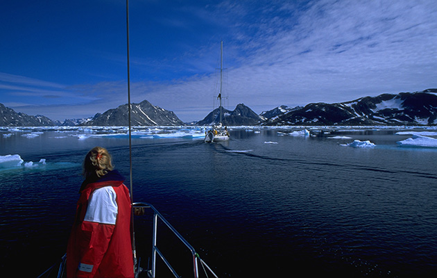
Glacial landscapes

Steep-sided , clean-edged fjords make it easy to navigate these coastlines but it can be hard to find an anchorage
Finding shelter in shallow water is the hardest part
Hewn from the bedrock by frozen rivers, glacial coastlines are comprised of steep-sided, clean-edged fjords and deep water. They can make for easy cruising grounds– aside from isolated hazards, what you see is what you get.
In most instances the centre line of a fjord will be clean and clear of dangers: ‘Just middle it’ is a common phrase we use on board.
In glacial landscapes the navigation tool of choice is usually the Mk 1 Eyeball. In part this makes sailing easier, but the echosounder will often bottom out over 150m and give erratic, often terrifying results when it picks up a scrambled message from the deep.
Easy navigation doesn’t mean easy cruising though. Finding shelter and shallow water for anchoring is often the hardest part of the passage – we have 80m of anchor chain on board and it’s regularly all out – but understanding the coastline helps.
In searching out an anchorage look for low-lying land, rivers which might have washed out some silt, gently shelving banks or a bend in the fjord where moraine (a kind of glacial gravel) has built up.
Many of the Icelandic fjords have an ‘eyri’ where moraine has curved around to form a spit, behind which you can usually find shallow and sheltered water.
Rias

Though the word Ria transports the mind to Spain, the UK has several of its own, including Falmouth, Salcombe and Portsmouth among others
Beware of isolated rocky outcrops and mud banks
Rias are submerged river valleys and form some of the best cruising grounds in the world.
The Scottish lochs, Portsmouth, Falmouth, Galicia and New England are all areas dominated by rias. They make good cruising grounds because they create deep but sheltered natural harbours.
There are often small inlets to explore and the bottom is likely to be mud, which makes for easy anchoring.
The location of the original river bed may be quite obvious on the chart and form a distinct deep water channel within the rias, but it can be almost invisible to us on deck.
This can catch out the unwary navigator – a ria might look several miles wide but much of it may be shoal. Hazards to watch out for are isolated rocky outcrops, steep mudbanks on either side of the riverbed and twisting channels within what looks like an open body of water.
The beauty of rias is that you can use all your navigational skills: depth contours will help to locate the channel, the surrounding land is usually prominent enough for visual navigation, you can read the landscape to identify areas of rock or mud, and areas that are steeply or gently shelving.
Rivers

As the river narrows from the estuary, silty, muddy banks show an area of sediment deposition which could extend into the channel
Shipping is one of the key issues on rivers
Many of the world’s major ports are up a river, and one of my favourite voyages is sailing up the Thames to the heart of London. Two worlds collide: the vast emptiness of the ocean and the intensity of urban life. You need to be totally tuned in to the world around you, watching out for shipping and monitoring the echo sounder.
Unlike a fjord, where the deepest water is usually in the middle, a sinuous river is less predictable. Deep water is often found in the outside bend and shallow water lies where the current is weaker on the inside.

Motoring up the Thames
According to Rule 9 of the IRPCS, vessels which can safely navigate outside the limits of a narrow channel should not impede the safe passage of vessels which can only navigate within it.
On major waterways this means most yachts need to keep clear of larger ships. Bear in mind that at low water the traffic will be squeezed into a narrower channel – timing your approach for closer to high water on busy rivers can help.
On rivers with few navigational marks look at the gradient of the banks to read the shape of the bed – the steepness usually correlates below water.
A low water approach is best as it exposes the shape of the river bed.
Barrier Islands

Strong currents carve out waterways in the sand making it easier to navigate these types of coastline
Shifting sandbanks can make charts out of date quickly
The north coasts of Holland and Germany are home to a shallow inland sea called the Waddenzee, which lies behind the Frisian Islands, a protective band of sand dunes.
Formed by thousands of years of waves depositing sand along the coast they are a type of coastline known as Barrier Islands. This constantly evolving land form can be found all over the world.
Rachael Sprot is a Yachtmaster ocean instructor and director of Rubicon 3, the offshore yacht sailing school
They usually form in areas with a tidal range of 1-2m and a large fetch. Although the range isn’t great there can be strong tides running between the islands.
The strong currents carve out waterways within the shallow sea behind, many of which are navigable by yachts at high tide as long as you can find your way around the muddy labyrinth.
Eyeball navigation is tricky here, as the islands themselves will be low lying without prominent natural features and the water is rarely clear enough to see the bottom.
Many of the deeper channels are well marked by buoys or withies – with a good pilotage plan and a keen eye on the depth you can spend days exploring.
If you can’t work out which side of a channel you’re on, turn slightly off to one side and see how the echosounder responds.
Up-to-date charts are essential on these waterways because the approach channels can change position frequently.
If you decide to explore beyond the main ports, which are usually dredged and well buoyed, wait for a rising tide and ensure your yacht is designed to withstand the odd bump in the mud as it’s more or less inevitable!
Deltas & Estuaries

Eyeball pilotage is possible in clear water, like here in Devon’s River Erme, but won’t work in the silty waters of the East Coast
Often a well-lit estuary can be easier to approach at night
Where a river escapes the confines of its banks and meets the sea, an estuary is formed. The river sediment is deposited at the mouth forming sandbanks and mudflats.
At first glance estuaries may seem similar to barrier island coastlines, but they are actually the opposite. A barrier island coastline is like a tree: you enter through the trunk-like gaps between islands and as you move inshore the waterways become more fragmented and tortuous.
With an estuary, you approach through a maze of channels to arrive at the trunk of a major river. Seen from above, estuaries are often more sand than sea.
The major difference to the sailor is that you make an approach through the complex shallows of an estuary in open sea conditions.
In tidal areas there can be cross currents sweeping through gaps in the sand banks, so take every opportunity to observe the actual current conditions on fixed objects.
Eyeball pilotage techniques are unlikely to help you here. On the fringes of a major river delta the land is often low lying with precious little to see except fifty shades of beige.
You need a keen eye on the echosounder and an easily identifiable route to make a safe approach.
Often a well-lit estuary is easier to approach by night than by day because you can pick up the marks from further away, and with the individual flashing characteristics of each light there’s far less chance of getting confused.
Coral Reefs

Differing depths are easy to spot thanks to the change in the sea’s colour, helping you to navigate the coastline
Practise eyeball navigation, noting the sea colour change
Crystal clear water, palm-fringed beaches and a water temperature of over 20°C – these are the cruising grounds we all dream of. But despite their appeal these desert island paradises are not without challenge.
Coral forms a barrier reef around many of these islands, which needs very careful negotiation before you can anchor safely inside its protection.
GPS is only useful if you have an accurate chart and in many of these areas the chart surveys are old, incomplete or simply not detailed enough.
In clear water with a sandy bottom you can tell the depth from the colour: the deeper the water the darker the blue.
Practise getting your eye in by checking the water colour against known depths so that when it becomes critical you can confidently pick your anchorage from 500m away.
Coral itself is hazardous: it gives a totally irregular bottom, grows up to 10cm per year and can be as hard as concrete if you hit it.
But with the sun above you and a good pair of polarised sailing sunglasses you can easily pick out the coral heads in calm water, especially if you can acquire some height by sitting a sharp eyed crew on the lower spreaders or the bow as a spotter.
Plan your approach for light, offshore winds when the surface of the water won’t be too disturbed. Make sure you agree some hand signals beforehand – is your spotter pointing towards the hazard, or showing you the direction to go? It’s a critical difference!
Volcanic Islands

With few natural inlets, most of the harbours are manmade
Oceanic swells can cause berthing issues
From the Faeroe islands to the Azores and from Hawaii to the Canaries, volcanic islands flung out in the middle of an ocean often form major staging posts on any number of world sailing routes.
Having erupted from the seabed they are usually steep-to, often with towering vertical cliffs or fringed by swathes of black beaches.
With few natural inlets marine activity is often limited to man-made harbours, and it can be hard to find protection from swell. Generally the waters are deep and clear of hazards but there are similar challenges to those faced in glaciated landscapes when it comes to stopping for the night.
In fact, with an omnipresent surge in many of the North Atlantic islands you’re often more vulnerable entering a harbour or tied up alongside than you are out at sea.
Give the coast a wide berth if there’s any kind of onshore swell and beware of entering harbours where there is visible surge on the breakwaters unless it’s a clear, wide entrance.
Once alongside use anti-chafe and surge protection on your lines – even in fair weather the swell conditions can deteriorate rapidly from a low pressure system hundreds of miles away.
Enjoyed reading Navigation masterclass: 7 coastline types?
A subscription to Yachting Monthly magazine costs around 40% less than the cover price.
Print and digital editions are available through Magazines Direct – where you can also find the latest deals.
YM is packed with information to help you get the most from your time on the water.
-
-
- Take your seamanship to the next level with tips, advice and skills from our experts
- Impartial in-depth reviews of the latest yachts and equipment
- Cruising guides to help you reach those dream destinations
-
Follow us on Facebook, Twitter and Instagram.


