The RYA Yachtmaster is a good test of advanced seamanship, but the best sailors know that there will always be lessons to be learned from experience
Yachtmaster Plus – Lessons learned from experience Part 5
PASSAGE PLANNING
Look at the sky
Duncan Wells
RYA instructor Duncan Wells is principal of Westview Sailing. He sails a Hallberg-Rassy 352
No one, on any RYA course I’ve attended, has ever pointed out that the time of High Water Springs for a given port will always be at the same time, give or take 45 minutes either side. Southampton High Water Springs will be about 1200 or 0000 and Portsmouth approximately 1250 or 0050. Neaps is six hours different from this.
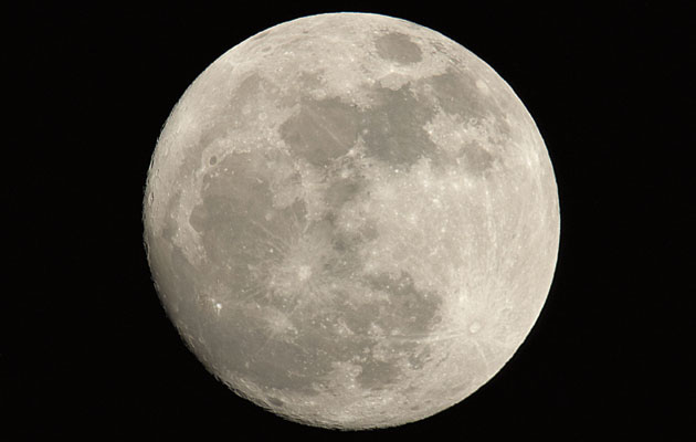
They also never tied in the weather with the broader business of sailing and navigating. For example, if you look at the night sky and there’s a full moon, you know it is Springs and that HW Portsmouth will be roughly 1250 or 0050. You know the tide turns in the Solent to ebb one hour before HW Portsmouth. So, if you are down by Calshot spit by 1150, you will take the ebb tide down the Western Solent and out into the Channel. You also know that the weather is likely to be fair, high pressure – you can see the moon – and that tells you the wind is likely to be light and probably from the north. You can check the time of HW from an Almanac, of course, and get a weather forecast, but just spotting that full moon will tell you a great deal.
Avoid rash decisions
Bill Anderson
YM’s seamanship guru Bill Anderson is the former RYA training manager who redesigned the Yachtmaster courses
The starting point for planning any passage is usually the earliest time we can conveniently set out, but avoid committing to a specific time of arrival, because conditions may change along the way. Tradition demands that the heading in a log entry is ‘From… Towards…’ not ‘From… To…’ Some of my worst decisions at sea have been made because I forgot this important principle – to stick to my plan I have just pushed onwards, forcing both my boat and crew to work much harder than was really safe.
The favoured tack
Duncan Wells
Pay close attention to which tack is the most direct. As a result of lee bowing one of your tacks will be more efficient than the other. On a long run this can make a big difference.
Height of tide
Duncan Wells
If you intend to sail during an ebbing tide, work out the height of water for every hour you will be out, so you know where you’ll have enough water and where you won’t. And always establish what your depth sounder is calibrated to – depth of water below the keel or total depth of water.
Don’t go out
Duncan Wells
Yachtmaster students have to go out whatever the weather but remember – if you are not taking an exam you don’t actually have to go out. It’s always a lot wiser to not to go out at all, rather than risk it and later regret it.
NAVIGATION
Handy measurements
Tim Bartlett
Tim Bartlett is a widely respected author of practical and technical sailing guides
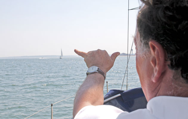
You can use your hands and fingers to measure – or at least estimate – angles. If you stretch one arm out in front, you will find that the width of your little finger is about one degree; the width of your three other fingers (the boy scout salute) is about 5°; your clenched fist is about 10°; the furthest you can stretch between your thumb and first finger is approximately 15°; and the furthest you can stretch your thumb and little finger is roughly 25°.
This is useful when pointing out inconspicuous landmarks. You can say: ‘the buoy three fingers left of the headland’, and be fairly certain they’ll be looking at the same one as you!
Vertical or tilting buoys
Duncan Wells
It took me 20 years to discover why some buoys are shown tilted on the chart and some are show straight up. Tilted marks are floating buoys and straight up marks are beacons, which are fixed to the ground.
The Rule of Quarters
Bill Anderson
Modern tide tables have easy-to-use diagrams to help us predict tidal heights and the software in many chartplotters gives us instant tidal heights. The short cut method most of us were taught is the Rule of Twelfths. But when we most need a quick approximation of tidal height, approaching an anchorage late in the evening, we probably don’t have a tide table or chartplotter immediately accessible in the cockpit and our tired brains struggle with dividing by twelve and multiplying by something else.
Most of the time, we only want an approximation and often we are sailing in waters with a tidal range of no more than around four metres. The quickest and easiest way to
get an acceptable estimate is by using the reliable Rule of Quarters:
The tide rises or falls by a quarter of the range in the first and last two hours of the flood and ebb and by a quarter of the range in each of the middle two hours. Simple.
But don’t use it unless you are quite sure that the tidal curve is reasonably smooth, symmetrical and undistorted.
Know where your horizon is
Tim Bartlett
The distance to the horizon (in miles) is twice the square root of your height of eye in metres. So if you are standing in the cockpit of a small boat, it is about three miles; if you are standing on the cabin top, it is about four miles. If you can see the waterline of another vessel, it is less than three miles away. If the horizon is ‘fuzzy’, the visibility is less than three miles. Extend the principle to work out when lighthouses will ‘rise’ above or ‘dip’ below the horizon. The dipping distance is the lighthouse’s horizon distance plus your own: a 50m high lighthouse will have a horizon distance of about 14 miles, so if your horizon distance is three miles, the lighthouse should rise or dip at about 17 miles.
Trust your chartplotter
Bill Anderson
Forget about chartwork, just drive the dot across your chartplotter screen! Purists will be heart-broken to hear that it nearly always works. Indeed, so reliable have I found it that I now go to places where the chartplotter is the simplest and therefore primary means of navigation.
But before you follow my slovenly example, you have to be able to answer yes to the following two questions: Can I keep a check on safe depth by using the echo sounder? And if I lose power or the satellites, can I stop and anchor or turn to seaward and sail safely out into deep water?
Never assume you can always look at the dot on the screen and know where you are. If it fails, you’ll feel pretty stupid if you haven’t recorded a recent position in the log or on a paper chart.


