Back of the Wight
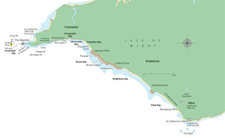
As mentioned, the chalk spine of the island dips to the north. Above, or north of it you’ll see tertiary sand, clay and limestone while south, of it, much older cretaceous strata are revealed. Freshwater is towards the bottom of the chalk layers and dinosaur fossils have been found, including the remains of mammoth, primarily teeth, in the Pleistocene-era chalky gravel either side of Freshwater.
East of Freshwater is Compton Bay, where the chalk gives way to Wealden, the oldest Cretacious strata, which is mud and sandstone from a former ocean bed, renowned for its richness in dinosaur fossils, including a well preserved trail of giant footprints of Iguanadon, some 3ft long, which fed on the trees, now petrified, that are still visible at low tide.

The southwest coast is divided into a series of bays, each separated by a ledge. Brook Ledges at Shippard’s Chine separate Compton and Brighstone Bays, and Atherfield Ledge separates, Brighstone and Chale Bays.

Brook Ledges are marked by a stubby pillar known as The Thimble, which was built in 1911 using concrete filled sandbags to mark the easternmost end of Fort Redoubt’s firing arc. It’s not a marker for rocks though, which extend well beyond the Thimble. Lying in wait off Brook Ledge are Sovereign Rocks, overlooked from the trees above Brook by Brook Hill House, JB Priestley’s home for many years.


Hardman Rock lies offshore from Chilton Chine. During the Round The Island Race, some crews will sneak inshore to escape the generally foul tide and take advantage of back eddies in the bay, but many are caught out by these ledges so it’s safer and more relaxing to stay 1km offshore in soundings of 5-10m.


